Drone photography spots in Uganda

Uganda Equator: A Complete Guide to Africa’s Famous Zero Latitude Crossing
July 26, 2026
Ziwa Rhino Sanctuary: The Story Behind Uganda’s Returning Rhinos
August 26, 2026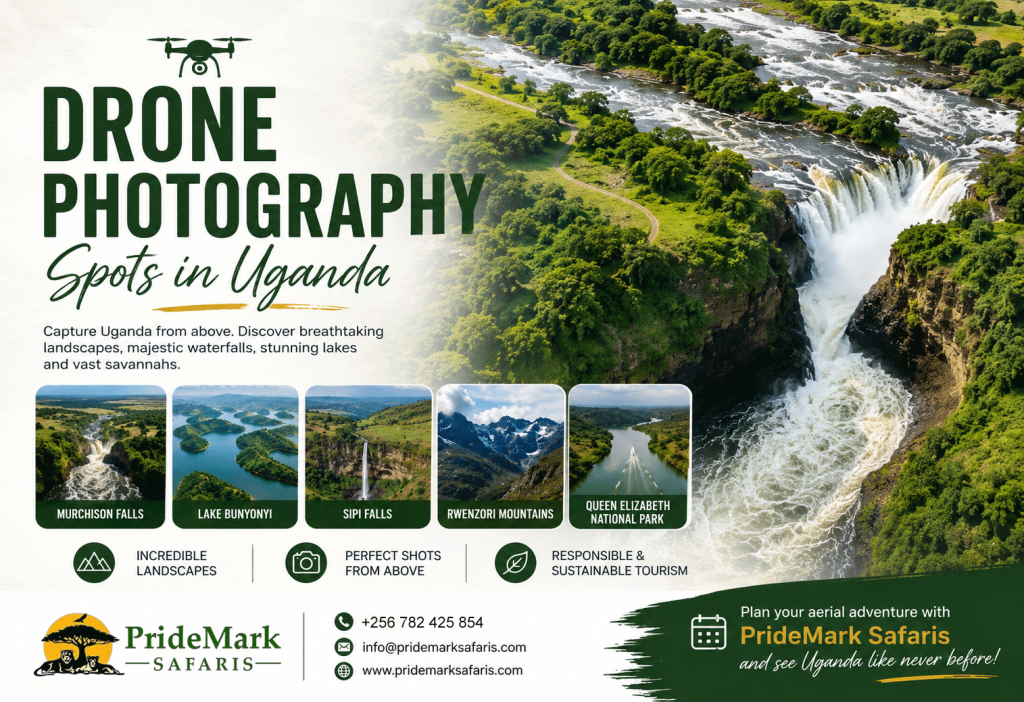
Drone Photography Spots in Uganda: 8 Incredible Landscapes to Capture from Above
Uganda is one of Africa’s most rewarding destinations for photographers. The country combines vast savannahs, dramatic mountains, winding rivers, crater lakes, waterfalls, tropical forests, and peaceful highland communities. From the powerful Victoria Nile at Murchison Falls to the terraced hills around Lake Bunyonyi, Uganda offers landscapes that become even more impressive when viewed from above.
For photographers and filmmakers, drone photography spots in Uganda offer a chance to present the country from a completely different perspective. Aerial photography can reveal patterns that are difficult to appreciate from ground level. Rivers become sweeping lines across the landscape, islands form beautiful geometric shapes, and mountains appear even more dramatic against the surrounding plains.
However, drone photography in Uganda requires careful planning. The country regulates unmanned aircraft operations through the Uganda Civil Aviation Authority (UCAA), which publishes specific regulations, requirements, registration information, and clearance procedures. Protected areas also have their own rules. Therefore, photographers should secure the necessary approvals before launching a drone.
For travelers who want to combine photography with an authentic safari experience, PrideMark Safaris can help create an itinerary around Uganda’s most photogenic landscapes.
Why Uganda Is Perfect for Aerial Photography
Uganda’s geographical diversity makes it particularly attractive for aerial photography. The country stretches from the volcanic mountains of the southwest to the savannah plains of the north and the forested landscapes of the west. It also contains large lakes, rivers, wetlands, waterfalls, cultivated hills, and protected wildlife areas.
The advantage of a drone is its ability to show how these features connect. A photograph of Lake Bunyonyi, for example, can capture not only the water but also the surrounding hills and scattered islands. Likewise, an aerial view of Murchison Falls can show the Nile approaching the narrow gorge before the water plunges through it.
Uganda Tourism Board describes the country as a destination with diverse wildlife, landscapes, and cultural experiences. Its official tourism information highlights attractions ranging from Bwindi and Murchison Falls to the Rwenzori Mountains.
That diversity creates endless possibilities for photographers. PrideMark Safaris can therefore combine traditional photography, wildlife viewing, cultural experiences, and carefully planned aerial photography into one Uganda adventure.
Best Drone Photography Spots in Uganda
1. Murchison Falls and the Victoria Nile
Murchison Falls is one of the most spectacular drone photography spots in Uganda. Located within Murchison Falls National Park, the waterfall forms where the Victoria Nile forces its way through a narrow gorge before plunging approximately 43 metres. The gorge itself is only about 7 metres wide at its narrowest point.
From the air, the scene becomes particularly dramatic. The camera can reveal the contrast between the powerful white water and the dense green vegetation surrounding the Nile. An aerial composition can also follow the river as it approaches the gorge, creating a strong leading line through the photograph.
The surrounding Murchison Falls landscape adds even more possibilities. The park contains broad savannahs, woodland, riverine environments, and wildlife. Uganda Tourism Board has highlighted the park for its wildlife and sunrise experiences, including elephants, buffaloes, lions, giraffes, birds, and other species.
For photographers, sunrise and late afternoon can produce beautiful light across the landscape. However, Murchison Falls lies within a protected area. Drone operators should therefore obtain the required permissions before flying. UWA’s published tariff information specifically recognizes commercial filming and photography involving drones and states that prior booking is required.


2. Lake Bunyonyi and Its Terraced Hills
Lake Bunyonyi is another exceptional choice for drone photography spots in Uganda. Located in southwestern Uganda near Kabale, the lake is surrounded by steep green hills and numerous small islands. The landscape looks particularly impressive from above because the water, islands, cultivated slopes, and winding shoreline create natural patterns.
An aerial photograph can show the relationship between the lake and the surrounding settlements. It can also capture boats moving across the water while keeping the highland landscape in the background. This creates a sense of scale that ground photography often cannot achieve.
Lake Bunyonyi sits at about 1,962 metres above sea level. Wikimedia Commons records the lake at roughly 25 kilometres long and about 7 kilometres wide.
The destination also works well as part of a broader southwestern Uganda itinerary. Travelers can combine Lake Bunyonyi with Bwindi Impenetrable National Park, Mgahinga Gorilla National Park, Lake Mutanda, and the Kisoro highlands.
For PrideMark Safaris, Lake Bunyonyi provides an ideal photography stop after gorilla trekking or before continuing toward Rwanda. Aerial images of the lake can also make excellent travel campaign material.


3. Sipi Falls and Mount Elgon
Eastern Uganda offers a completely different visual experience. Sipi Falls sits in the foothills of Mount Elgon near Kapchorwa. The area is famous for its waterfalls, steep cliffs, green vegetation, coffee farms, and mountain scenery.
Sipi Falls is one of the most interesting drone photography spots in Uganda because aerial photography can capture the waterfall within its larger landscape. Instead of photographing only the falling water, a drone can show the cliff, surrounding vegetation, farms, valleys, and distant slopes.
The area contains several waterfalls rather than a single cascade. This gives photographers multiple compositions to explore. A high viewpoint can emphasize the height of the falls, while a lower angle can focus on the relationship between the waterfall and the surrounding cliffs.
Sipi also offers opportunities beyond the waterfalls. The surrounding agricultural landscape creates striking patterns, especially where cultivated slopes meet natural vegetation. Photographers visiting with PrideMark Safaris can combine aerial photography with hiking, coffee experiences, cultural visits, and nature walks.


4. Rwenzori Mountains
The Rwenzori Mountains provide some of Uganda’s most dramatic mountain scenery. UWA lists the Rwenzori Mountains among Uganda’s national parks, while Uganda Tourism Board promotes hiking experiences in the range.
For aerial photographers, the Rwenzori landscape offers rugged ridges, deep valleys, forests, alpine vegetation, and high-altitude scenery. On clear days, aerial images can emphasize the contrast between the mountain slopes and the surrounding lowlands.
The mountains are especially attractive for photographers who want something different from Uganda’s classic safari scenes. Instead of focusing on animals, aerial photography here can concentrate on topography. The lines created by ridges and valleys can produce powerful compositions.
However, mountain weather can change quickly. Clouds and mist often become part of the visual character of the Rwenzori. Rather than treating them as a problem, photographers can use them to create atmospheric images.
A PrideMark Safaris Rwenzori adventure can combine trekking photography with carefully planned aerial work where the necessary approvals allow it.


5. Queen Elizabeth National Park and the Kazinga Channel
Queen Elizabeth National Park offers another fascinating landscape for aerial photography. The park contains savannah, lakes, wetlands, forests, crater landscapes, and the famous Kazinga Channel. UWA lists Queen Elizabeth among Uganda’s national parks, while Uganda Tourism Board highlights the park for game drives and boat cruises along the Kazinga Channel.
From above, the Kazinga Channel creates an excellent natural line through the landscape. Aerial photography can capture the relationship between water, vegetation, islands, and surrounding plains.
The park also provides opportunities for wildlife photography. However, drone operators must exercise particular care around animals. A drone should never be used to chase, disturb, approach, or stress wildlife. The goal should always be to photograph the landscape responsibly.
Queen Elizabeth National Park is also attractive because it can form part of a longer western Uganda circuit. PrideMark Safaris can combine the park with Kibale Forest, Bwindi, Lake Bunyonyi, and the Rwenzori region.


More Drone Photography Spots in Uganda
6. Lake Mutanda and the Kisoro Highlands
Lake Mutanda sits near Kisoro in southwestern Uganda. Its surrounding volcanic landscape makes it a strong choice for landscape photography. The lake reflects the surrounding hills, while distant volcanic peaks can add depth to an aerial composition.
The area becomes particularly attractive when the weather creates layers of mist across the hills. A drone can reveal the lake’s position within the broader highland landscape.
Travelers visiting Bwindi or Mgahinga can also consider adding Lake Mutanda to their itinerary. PrideMark Safaris can incorporate this region into a photography-focused southwestern Uganda trip.
7. Lake Mburo National Park
Lake Mburo National Park offers a different visual style from Uganda’s western mountain landscapes. The park contains rolling savannah, wetlands, woodland, and the lake itself. It also provides opportunities to photograph zebras, antelopes, buffaloes, and other wildlife from approved viewpoints.
For aerial photography, the landscape is most interesting when the photographer focuses on patterns rather than individual animals. The lake, vegetation, trails, and open plains can create strong compositions.
Because Lake Mburo is a protected area, drone operations must follow the relevant UWA and UCAA requirements. PrideMark Safaris can help travelers plan their photography schedule around permitted activities.
8. Kidepo Valley National Park
For photographers seeking dramatic wilderness, Kidepo Valley National Park deserves attention. The park lies in northeastern Uganda and features broad valleys, rugged mountains, open plains, and distinctive dry-country scenery.
The landscape looks particularly different from the lush southwestern parts of Uganda. Aerial images can emphasize the contrast between the open valley floor and the surrounding mountain ranges.
Kidepo also has an important conservation story. In March 2026, Uganda Tourism Board reported the return of southern white rhinos to Kidepo Valley National Park after more than four decades.
For photographers, that development adds another reason to follow the region. However, wildlife remains the priority. Drone operators should only fly where authorities permit it and should avoid disturbing animals.
Drone Photography Spots in Uganda: When Is the Best Time to Shoot?
The best time depends on the landscape you want to photograph. Early morning usually provides softer light and calmer conditions. It can also produce mist around lakes and mountains. Golden-hour light later in the day can create long shadows across hills, savannah, and waterfalls.
Weather matters just as much. Uganda’s landscapes can change dramatically between sunny and cloudy conditions. A partly cloudy sky may actually produce more depth than a completely clear sky.
Photographers should also watch wind conditions. Mountains and open landscapes can produce unpredictable airflow. Waterfalls can create mist, while highland areas can experience sudden weather changes.
A good photography itinerary should therefore avoid packing too many locations into one day. PrideMark Safaris can help photographers allocate enough time at each destination to wait for the right light.
Uganda Drone Laws and Permissions You Should Know
This is one of the most important sections for anyone planning drone photography spots in Uganda.
Uganda regulates unmanned aircraft operations through the Uganda Civil Aviation Authority. The UCAA provides an official drone section with information on registration, requirements, clearance procedures, and the Civil Aviation (Unmanned Aircraft Systems) Regulations, 2022.
Therefore, visitors should not assume that owning a drone automatically gives them permission to fly it.
If your photography takes place inside a national park or another protected area, additional authorization may apply. UWA’s published conservation tariff specifically includes commercial filming and photography. It also lists separate treatment for filming with a drone and states that prior booking is needed.
This matters for popular locations such as Murchison Falls, Queen Elizabeth, Bwindi, Kidepo, Lake Mburo, and the Rwenzori Mountains.
Airport areas also require special caution. UCAA states that photography and filming within sensitive operational areas at Entebbe International Airport require prior permission.
Before a trip, photographers should therefore:
- Confirm current UCAA drone requirements.
- Complete any required registration or clearance.
- Obtain the necessary permission for the intended location.
- Check UWA requirements before flying inside protected areas.
- Respect wildlife and local communities.
- Avoid flying close to people without appropriate authorization.
- Avoid sensitive security and aviation locations.
- Check weather and wind conditions before every flight.
- Carry documentation showing the relevant approvals.
For current requirements, consult the Uganda Civil Aviation Authority drone information page and Uganda Wildlife Authority before traveling.
Responsible Aerial Photography in Uganda
Great aerial photography should never come at the expense of conservation. Uganda’s national parks protect ecosystems that support wildlife and communities. A drone that flies too close to animals can create unnecessary stress and disrupt natural behavior.
Photographers should also respect people. Ask for permission before deliberately filming individuals, homes, private property, or community activities. A beautiful aerial photograph should tell a story without compromising someone’s privacy.
The same principle applies to sensitive environments. Avoid unnecessary flights over breeding areas, nesting sites, wildlife concentrations, and other locations where a drone could cause disturbance.
UWA emphasizes conservation, community involvement, sustainable tourism, and environmental protection across Uganda’s protected areas.
This is why PrideMark Safaris encourages travelers to treat drone photography as part of responsible tourism rather than simply another way to collect impressive images.
Tips for Getting Better Aerial Photos in Uganda
A drone does not automatically produce a great photograph. Composition remains important.
First, look for leading lines. Rivers, roads, shorelines, and valleys can guide the viewer through the image. Second, search for patterns. Agricultural fields, islands, forest edges, and savannah can create strong geometric compositions.
Third, consider scale. A person, boat, vehicle, or small building can help communicate the size of a landscape. However, always ensure that filming people remains respectful and permitted.
Fourth, experiment with height. The highest possible altitude does not always produce the best image. Sometimes a lower viewpoint creates stronger textures and more depth.
Finally, plan around light. Sunrise can create soft shadows across mountains and valleys. Sunset can add warmth to hills and waterfalls. Overcast conditions can also work well for forests and waterfalls because they reduce harsh highlights.
With good planning, PrideMark Safaris can help photographers build an itinerary that combines the best light, landscapes, wildlife experiences, and cultural encounters.
Explore Uganda from a New Perspective with PrideMark Safaris
Uganda is already spectacular from the ground. From the air, its landscapes tell an even broader story. The winding Nile at Murchison Falls, the islands of Lake Bunyonyi, the cliffs of Sipi Falls, the Rwenzori peaks, and the waterways of Queen Elizabeth National Park all offer distinctive photographic opportunities.
The best drone photography spots in Uganda are not simply places where you can fly a drone. They are places where geography, light, culture, wildlife, and landscape come together to create a memorable visual story.
With careful planning and the right permissions, photographers can explore Uganda responsibly while creating images that showcase the country’s extraordinary beauty.
PrideMark Safaris can help you design a Uganda photography adventure around the landscapes you most want to capture. Whether you want waterfalls, mountains, lakes, wildlife, forests, or wide-open savannah, Uganda offers an incredible canvas for aerial storytelling.